Archive for category News
Changes
It is now official. I will retire at the end of March.
Around the middle of April, I will get on my bike and head to the west coast.
This trip has been cooking in my head for years. I wish that I could have done it while I was younger, but I could not see a way to take three months off work.

My route takes me straight north to Berea, Ky. There is a proposed USBR 21 route ( Tennessee and Kentucky; note that they don’t match up at the border, but the Bluegrass route makes the connection). However, I am inclined to ride pretty much straight up US 25, which parallels I-75. USBR 21 takes a scenic and low-traffic route, but the USBR route is a few days longer and I am itching to get on the Trans Am route. I have generally found that federal highways that follow interstates in rural areas have low traffic volumes and friendly cross sections. USBR 21 and Bluegrass will be plan B if riding is unpleasant.
In Berea, I join the Adventure Cycling TransAmerica Route. I will stick with the TransAm as far as Pueblo, CO, where I get on the Western Express Route to San Francisco.
From San Francisco, it’s up the coast (Pacific Coast Route). I will cut across the Coast Range at some point, probably Crescent City, and freestyle over to Medford, probably through the Applegate Valley. I have not yet decided the route from there, but I plan to head north to Portland (the route may include part of the Oregon Outback route) and end the trip at Pendleton. I have people to visit in San Francisco, California coast, Medford, Portland, and Pendleton. I seems like the Willamette Valley would be a little tame by this point in the trip; on the other hand, it may be just what I need, so I may include Eugene (and there are people to visit there).
I regret that I will miss Flagstaff and Boulder City. Reaching those destinations woul d add a week or two. But any cousins who want to meet me on the road would be very welcome, though I completely understand the uncertainty of my schedule. And maybe there is a canyon and desert tour in the future.
The Adventure Cycling maps provide well-researched routes and include a lot of information about services along the way, so much of the uncertainty of unguided bike travel is eliminated. Once I get to Oregon, I feel more confident that I can find my way around, with help from google maps.
My touring bike was designed and built with this trip in mind, and I have been selecting equipment for a long trip for some time. I will continue obsessing about preparation and equipment for this trip. If you stick with me, you will read about equipment choices and training, but it is not that long before I launch if things go according to plan.

A Visit to Portland
 Portland is a wonderful place. Everybody knows it is the one of the best (link) cities if not the best city (link) in North America for cycling. The relatively compact development patterns (for a US city) means that distances between trip generators and destinations are small enough to make cycling practical for a lot of people. And there has been a lot of effort expended to create bike-friendly infrastructure.
 It’s also one of the best cities for mass transit (link), and includes real trolleys (with real steel rails) in the transit mix.
There is a little bit of a potential conflict here, as I discovered on a recent visit.
 My wife and I visited Portland recently, arriving May 19 for a two week visit to various Oregon destinations. I grew up Oregon, and some of my old friends have ended up in Portland, so I was planning to do some visiting, in addition to getting reacquainted with the city.
The first full day there, my wife was suffering from the remnants of a sinus infection and jet lag, so I left her at the hotel (recommended) and took the trolley to walking distance from the nearest bike rental shop . They set me up with a serviceable hybrid, and I took to the streets.
 It was a short ride to the river. After rolling along at the riverfront MUP for a while, I got onto the street again. I made a left turn onto a one-way street, looked over my right shoulder to check traffic before getting into the right lane, and Crunch! I was down hard. I failed to notice that there was a trolley track in the street that I just turned onto. I somehow made it to the sidewalk and called 911. It was clear that my left arm was broken.
 Surgery to install plates and screws and two nights in Good Samaritan (also recommended if you have the misfortune of needing their services) later, I was back on the street. The rest of the Oregon visit was less active than originally intended, but visits with family and friends (through the pain-med fog) meant that it was far from disappointing.
The hard cast came off July 11, the eighth week after the incident, and I wore a brace and did physical therapy for few weeks. I got permission to get back on the bike after eleven weeks (August 5). I am now in the 16th week of recovery, and things are getting back to normal. The arm still ain’t quite right, but it’s getting there.
I love Portland, and I even love the trolleys. The bike/trolley conflict is an open issue. For a first step, a little more warning would be nice. A few more signs like this might have saved me some pain and suffering. If you visit (or if you live there) just be real aware of where the tracks are.

Tumbling
Hurray for Knoxville! We have been recognized as a > Bicycle Friendly Community by the League of American Bicylists. (Photo from Bike Knoxville blog)

And we had our annual Neighborhood Bike Ride.

On the home front, I rode my first organized century since surgery back in February. My endurance and strength have been continuing to improve slowly but steadily, and I was thinking of this as a test that would tell me where I am fitness-wise. And maybe it would give me some clues about how much the old heart valve was affecting me, and what my potential for further improvement might be.
The ride was the SMW fall century, hich wanders the back roads from the town of Loudon to Tellico Plains and back. This is a very pleasant and scenic ride in the rolling hills of the Ridge and Valley Province, though woods, pastures, soybean fields, and a few big fields of switch grass. It skirts Tellico Reservoir and the sites of a cluster of Overhill Cherokee towns , one of which gave Tennessee its name. The ride has no big climbs, but not much of it is flat, either; some of the short climbs are steep enough that those of us who need to pace ourselves carefully are well advised to use low gears. I have ridden this event 4 or 5 times in the last 10 years, and my best time was just under seven hours in about 2005.

Part of the route
The temperature at the start was a little cool at about 50F, but I was comfortable in arm and leg warmers, full gloves, and a wind vest. The local patches of morning fog dissipated as it warmed up, and it turned into a glorious day of clear blue skies and foliage just hinting at autumn.
On many of these rides, I naturally fall in with a group of riders that is going about the same speed as me, though my tendency to stop only briefly at the rest stops often makes that more difficult. This time, I did not find a group that matched my pace well, though I took some opportunities to draft behind faster riders. When the 100-mile and the 62-mile rides split, several riders I was around took the shorter option, and I rode alone into Tellico Plains and on past there. Then at Madisonville, I left the rest stop with a group that had been going faster than me but appeared to be tiring, while I was still feeling good. I sat on with them for a few miles.
Then, about 80 miles and 5 hours into the ride, I noticed that my crank arm was about to fall off and I could not ride any farther. A couple of weeks before, I put on this cool SKF bottom bracket. Crank arms frequently require tightening a couple of times after being removed, and evidently I had not done this enough times. This was the first time in my decades of riding that I been stranded by making this beginner mistake.
I pulled out the cell phone and called for help. None of the support vehicles were anywhere close, but they sent one my way. Though frustrating because I had spoiled my chance to set a good time, the weather was so fabulous the wait was not at all unpleasant. Finally, about an hour after I stopped, I got into a car with my bike on a trunk rack, and we headed up the road 10 miles to the next rest stop, where the support crew had tracked down the 15 mm socket I needed to get rolling under my own power
After a few seconds with the wrench and topping off my water, I was back on the road. I was feeling great. An hour of rest helped, but I was feeling good before stopping. I had only about 10 miles to go and I was ready to cover some ground.
Just a few miles before the end I was catching up to another rider on a descent. I thought to myself, he sure is being a wienie on that curve … ohmygod yikes! Sound of skidding rear tire and the crunch of me and the bike landing in the ditch. In spite of riding this road before, I totally misread the curve and entered it way too fast. I checked myself over and found a few bruises and a cut just below the right knee. The bike was apparently undamaged, and after I got the front fender to stop rubbing I got back on and finished the ride. The cut on my leg was bleeding dramatically (with the help of Coumadin), and I stopped in the bathroom and cleaned it up. I ate the sandwich provided, schmoozed a little, and got the cut dressed. When I got on the bike to ride the 100 meters or so back to my car, I discovered that my tire was flat, so I walked.
After a 45 minute drive home, my knee had stiffened up a bit. By the time I put my gear away and got into the shower, the knee was swelling up and getting sore. By the end of the shower, it was clear that it needed some attention. Since it was Saturday evening and the next Monday was a holiday, the only real option was the emergency room. At the ER, I got x-rays and prescriptions for pain pills and anti-inflammatories. Nothing was broken (although there was an unexplained old bone chip floating around), but they could not tell if there was anything else damaged that would not improve on its own. For at least a couple of days, it’s rest, ice, elevation, anti-inflammatories, and crutches. I can’t do my regular weekend chores and I am mostly helpless.
It was a great ride on a wonderful day but I end up frustrated and stymied. I was riding better than I have for nearly 20 years, and I felt good enough that I probably could have gone faster. I messed up the ride with bad bike maintenance, and then I crashed badly enough that I will be off the bike for an indefinite period.
Energy and transportation
This Guardian article about efforts to reduce the environmental and energy impacts of road construction and maintenance (“America has 10% of the planet’s roads and building each mile of freeway uses as much energy as 200 US homes in a year”) got me to thinking about the proportion of US energy used by transportation.
The usual energy-consumption-by-sector statistics we see are something like this pie chart from this DOE report.
 The problem with this perspective is that it only considers the operational consumption of energy. Manufacture of vehicles and construction and maintenance of roads is not included. The above article made me wonder specifically about the relative amount of energy consumed by the latter.
With a little research, I found an article (Hybrid Life-Cycle Inventory for Road Construction and Use. G. J. Treloar, P. E. D. Love, and R. H. Crawford. ASCE Journal of Construction Engineering and Management. January/February 2004) that answers my questions. This chart summarizes the conclusions of the article (the caption is from the article).
 Life-cycle energy attributable to road construction and use. The step jumps in the line for vehicle manufacture and maintenance represent complete vehicle replacement at 15 year intervals. Increases in road life-cycle energy are due to the energy embodied in materials used for maintenance. Continuously reinforced concrete, CRC; fulldepth asphalt, FDA; deep-strength asphalt, DSA; deep-strength asphalt on bounded subbase, DSAB; plain concrete, PC; composite, asphalt, and concrete, Comp; granular, G; and asphaltic concrete on bounded subbase, ACB.
From this perspective, it looks like the total life-cycle energy cost (and carbon footprint) of road-based motor-vehicle-oriented transportation is 50% to 75% greater than the simplified energy-use-by-sector perspective offered by DOE. Of course, most of the “industrial” sector could probably be divvied up between the other sectors from a life-cycle perspective.
Aggregator February 6, 2010
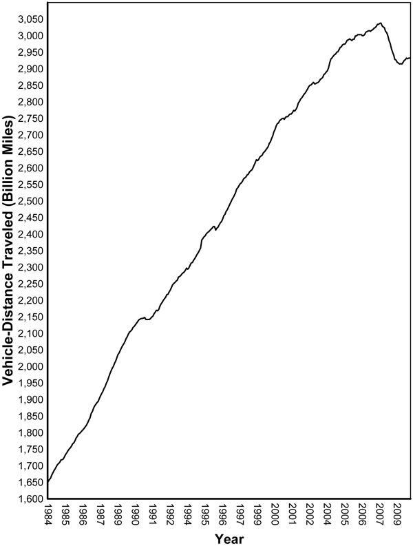
Motor vehicle miles traveled increased by 0.2% in 2009 ( FHWA report ) after decreasing in 2008. If you look at the trend, 2009 looks like a small correction, and we can hope that the reduction is permanent.
*****************************************************************************
Fla. deadliest state for walkers, cyclists ( USA Today). This study makes Tennessee look relatively safe.
Aggregator 1-3-2010
Posted by valvejob in Commentary, News on January 30, 2010
News of interest
Bicycling hits 1% of all trips, a 25% increase since 2001.
************************************************************************************
Utah groups advocate gas tax flexibility to allow money to be spent on mass transit. The Utah Constitution reserves gasoline tax revenues for highway construction and related purposes.
Meanwhile, California Governator Schwarzenegger has proposed a complex plan to help balance the state budget by cutting the gas tax, much of which goes to transit, and increasing the excise tax for gas, which can go in the general fund.
**************************************************************************************
Six good reasons that all commuting cyclists should have fenders. They have a little bit different perspective in places where cycling is taken seriously for transportation. I don’t see very many other cyclists on my commute, particularly on wet days. But where there lots of other riders, fenders can help keep other people dry, too.
**************************************************************************************
Fastest in the world. Articles on London 2012 Olympic velodrome in NCE, a British civil engineering magazine blog: design features and progress.

Aggregator 1-9-10
Posted by valvejob in Commentary, News on January 9, 2010
News of Interest
Denver has gone beyond mere Complete Streets to living streets . According to Gideon Berger, senior city planner with Denver’s Department of Community Planning and Development, “Complete Streets is about road building, but Living Streets is about city building”. More.
******************************************************************************
In New York, 240 parking meters are converted to bike racks.
And speaking of New York, Bike Kill is an annual bikecentric party that includes costumes, Tall Bikes and jousting with tall bikes, and bike gangs . And lots of beer. It is not exactly a Tweed Ride, though they both have some Steampunk tendencies. Video.

Image from Wired
*****************************************************************************
Is America’s love affair with the car fading? We don’t know why there are 4 million fewer cars on the road at the end of 2009 than a year before, but this article goes through the full range of speculation.
******************************************************************************
The American Society of State Highway and Transportation Organizations (AASHTO) is a powerful organization that helps set standards and directions for transportation in the US. They have compiled a list of their priorities for the new year . AASHTO has managed to get past the American transportation paradigm that has pushed more cars, more roads, and bigger roads for most of the last century. The list does include a lot of car-oriented stuff, but it also includes improving intercity passenger rail at number 2; reducing distracted driving (#4); recognition of the role of transportation in climate change (#6); and creating livable communities (# 10).
Aggregator 1-2-2010
Posted by valvejob in Analysis, Commentary, News on January 2, 2010
News of interest
FHWA Issues Final Rule for Revised Manual on Uniform Traffic Control Devices. There are several changes relevant to bike design, but the most interesting is that the shared lane marker, aka sharrow, is now vetted as a standard practice, so your local traffic jurisdiction no longer has an excuse not to use it if appropriate. The bike part of the document is available here.

Sharrow
*****************************************************************************
The New Republic notes that Americans are still driving less even though gas prices are down from their peak. Per capita mileage just begins to level off at the end of 2009 from a downward trend that started in 2005 or so. Sign of real change?

Miles driven per capita
****************************************************************************
Time has some more interesting details on the Netherlands’ road-use tax. Charging for each kilometer driven based on type of car and with higher rates for times of peak congestion seems like a good idea to me, but I can’t imagine it meeting with success in the hysterically tax-averse U.S.
*****************************************************************************
Older drivers face choice between safety and mobility. The mainstream media, in this case, the Washington Post, is becoming more aware of the isolating effect of car-oriented suburban living on people who can’t drive, in particular people getting too old to drive.
A well-designed community means that independence does not depend on the ability to drive.
*****************************************************************************
Bike and car production rates. I came across a file with this graph in it on Earth Policy Institute data center.

You can see the Bike Boom in the early 70’s and the mountain bike boom in the late 80’s, followed by doldrums in the late 90’s.
But it looks like the Bike Boom was no fluke (though there was an adjustment that marks the end of the period recognized as the bike boom). It actually looks like that inflection point in 1969 was the beginning of a long-term trend.
There is another file from the same source that shows where the production increases were; recently, all the growth is in China. It is no surprise to anyone that China is producing so many bikes, but it does suprise me that all other countries listed are shrinking, including Taiwan. U.S. bike production is a mere 3.4% of its peak.
| Year | China | Italy | Germany | France | Total EU-15 | Taiwan | Japan | United States |
| Million Units | ||||||||
| 1990 | 31.9 | 3.5 | 3.9 | 1.5 | n.a. | 6.8 | 0.7 | 5.6 |
| 1991 | 36.8 | 3.6 | 4.9 | 1.2 | n.a. | 7.7 | 0.8 | 7.6 |
| 1992 | 40.3 | 4.1 | 4.6 | 1.0 | n.a. | 7.5 | 1.0 | 8.9 |
| 1993 | 41.0 | 5.2 | 4.1 | 1.0 | n.a. | 7.9 | 1.0 | 7.7 |
| 1994 | 42.0 | 5.8 | 3.5 | 1.3 | n.a. | 9.2 | 1.1 | 7.3 |
| 1995 | 41.0 | 5.3 | 3.2 | 1.3 | n.a. | 9.7 | 1.8 | 8.8 |
| 1996 | 38.0 | 4.0 | 2.9 | 1.3 | n.a. | 7.4 | 1.5 | 8.0 |
| 1997 | 30.0 | 4.0 | 2.8 | 1.3 | n.a. | 11.9 | 1.8 | 6.0 |
| 1998 | 33.8 | 3.0 | 3.2 | 1.6 | 11.7 | 10.5 | 5.9 | 2.5 |
| 1999 | 42.7 | 3.2 | 3.2 | 1.8 | 12.1 | 8.4 | 5.6 | 1.7 |
| 2000 | 52.2 | 3.2 | 3.3 | 1.9 | 12.3 | 8.0 | 4.7 | 0.9 |
| 2001 | 51.2 | 2.7 | 3.0 | 1.6 | 10.5 | 5.0 | 4.2 | 0.9 |
| 2002 | 63.0 | 2.4 | 3.1 | 1.4 | 10.2 | 4.4 | 3.1 | 0.4 |
| 2003 | 73.0 | 2.6 | 3.2 | 1.5 | 10.4 | 4.3 | 2.5 | 0.4 |
| 2004 | 73.0 | 2.6 | 2.9 | 1.7 | 10.4 | 4.4 | 2.5 | 0.3 |
| 2005 | 80.7 | 2.4 | 2.7 | 1.7 | 10.3 | 4.7 | 1.9 | 0.2 |
| 2006 | 84.9 | 2.4 | 2.5 | 1.3 | 9.6 | 4.3 | 1.3 | 0.3 |
| 2007 | 87.0 | 2.5 | 2.4 | 1.1 | n.a. | 4.9 | 1.1 | 0.3 |
The abrupt downturn in US production in the late 90’s can be explained with this, from Wikipedia: ” In 1996, Murray Inc., the last major U.S. bicycle producers with Huffy and Roadmaster (formerly AMF), received a major blow when U.S. courts ruled that imports from China were not a ‘material threat’ to U.S. companies. Within three years, Huffy, Roadmaster and Murray ceased manufacture of bicycles in the United States.” (http://en.wikipedia.org/wiki/Murray_(bicycles))
The fact that production of bike units continues to grow faster than car production looks good, but how much of this is just mindless consumption of toys, fueled by planned obsolescence? And where do all these bikes go? Are they used briefly and thrown away?
River Bluff Wildlife Area
Posted by valvejob in News, scenery, Uncategorized on December 31, 2009
Wife, brother (visiting from LA), and I got a tour of the western anchor of the proposed Urban Wilderness and Historic Corridor . This parcel is now referred to as the River Bluff Wildlife Area, but most of us know it as the Rose Property.
There has been a bunch of new high-density development on top of this hill. High density is good, usually, but this area is too steep for high density, too poorly served by roads, and too far from services. It becomes high-density sprawl that requires car transportation, but the only access is by narrow, windy roads on the edge of a precipice, and through traffic bottlenecks. If this kind of development were to occur on the Rose Property, it would wreck the existing view of the wooded river bluffs currently visible from UT and Downtown.
The good news is that Legacy Legacy Parks just closed on the property, and this area will become part of the Knoxville parks system. The Legacy Parks Foundation welcomes contributions to support this and other purchases in the corridor.
 We started up by the water tower that now dominates the skyline. It is a symbol of bad planning, worse communication, and general ugliness.
There are woods, bluffs, and two ponds in the hinterland.

There is a little ice on the pond and at the outlet of the pond.

At the base of the river bluff there is an old road. It’s perfect for a trail, with potential for connection to a riverside greenway system (should the rest of the system ever happen).

And from the top of the bluff, there are views down stream (waste water treatment plant and university on right, UT hospital on left)…

And up river, toward down town…

**************************************************************************
In spite of the ugliness in context, the water tower looked kind of cool on the way out…

And here are a couple more out-of-context pictures:
Small glade cress, House Mountain, December 28
Neyland Stadium struggles to rise from the fog


Bike aggregator 3-13-2010
Posted by valvejob in Commentary, News on March 13, 2010
For all you Middle Earth fans, the Discovering Urbanism blog has this interesting discussion of why JRR Tolkien lived car free (makes you want to go out and buy something from the elves at Rivendell).
**********************************************************************************
The Washington Post announces dedicated bike lanes on Pennsylvania Avenue. The Post says, “The center of Pennsylvania Avenue from the White House to the Capitol soon may be reserved for just two things: the president’s inauguration and people riding bicycles.”
**********************************************************************************
Back home, the Knoxville Regional Transportation Planning Organization (TPO) bike plan was approved by the Knoxville-Knox County Metropolitan Planning Commission (MPC). The bike plan was on the consent agenda, so there was no controversy, but also no discussion and no press.
*************************************************************************************
As everyone probably knows by now, Google maps has launched a bike option for route finding. Reviews are mixed, with some reporting that Google generates routes that agree with routes they have developed through hard experience, and sometimes even provides new and better routes. Others report problems, such as Google routes on narrow, busy streets when more pleasant alternatives were available, or directing them to bridges where bikes were prohibited. My experience with Google was only fair; for Knoxville and environs, the TPO maps provide much more information. In addition, different individuals have very different ideas about what constitutes a good route, which is hard to capture with a single methodology.
However, it is great to see Google make this effort, which contributes to legitimizing and promoting bike transportation. Google reputedly accepts input, so the most egregious errors should be corrected quickly. And Google generates intercity routes that are worth considering, even if you don’t like the intracity routes.
*************************************************************************************
Michael Musto, Village Voice columnist and cable commentator, is featured in this Streetfilms bike commuting video. I guess it’s nice to see celebrities celebrated for living car free, but I gotta say, don’t ride like Musto. He rides too close to parked cars and between lines of moving motor vehicles. He’s gonna get doored or worse.
**********************************************************************************
The National Highway Traffic Safety Administration issued a report on road motor vehicle fatalities for 2009. It is odd that we can celebrate a decrease to “only” 34,000 deaths in one year (over ten times 9/11), but we have become inured to this carnage as the price we pay for automotive convenience. This is the lowest total since 1954, and the fatalities per million mile rate is steadily declining.
It doesn’t look so good around the world. NGH posted this summary of a World Health Organization report on world road safety. According to NGH, “Around the world, approximately 1.3 million people die each year on the roads and between 20 and 30 million sustain non-fatal injuries …”; “If trends continue unabated deaths will rise to an estimated 2.4 million a year by 2030.” This is another reason that car-dependent development is a very poor model for the developing world to emulate.
Bike advocacy, Bike transportation, Knoxville cycling, traffic safety, transportation costs and planning
Leave a comment